
Mt Rogers
| Virginia |
Elevation: 5,729'
Vertical Gain: 1530'
Vertical Gain: 1530'
Date: April 18, 2011
Time: 9:20 AM
Time: 9:20 AM
Weather: Chilly, light overcast
Party: Bob, Kevin
Party: Bob, Kevin
Today, Kevin and I set out on a week long trip which will set our single trip record by achieving
eight state high points. Once again - with concerns about finding time during the summer
between Kevin's summer job, summer classes, and an early return to college for the fall soccer
season - we are taking advantage of his Spring break and heading to the warmer states of the
southern Appalachian Mountains. This trip is significant for two reasons - it will put us well
past the halfway point and it will cover the last of the climb vs drive options.
We set out from home in New York's Hudson Valley on a Sunday just after 6:00 AM, arriving at
Grayson Highlands State Park in Southwest Virginia by 5:00. With each of us taking two and a
half hour driving shifts the trip didn't seem too bad. The day ended with a four mile hike from
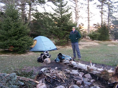
the overnight parking area on a connecting trail to the AT, then north on the AT to a nice
camping spot a little short of the Thomas Knob shelter. We didn't realize at the start that this
connecting trail added more than a half mile than the one from the neighboring day use
parking lot but it did give us some nice alternative scenery of the sometimes bare, pasture-like
hilltops. They weren't just "pasture-like", they were actually pasture as we found out when we
ran into a small herd of the wild ponies we had heard about. (Not that the manure piles were a
clue.) A few more ponies crossed the trail right in front of us in a wooded section right near
where we camped. The large, rising, full moon that evening was awesome and so bright at
night it left shadows and limited the number of stars that could be seen. Kevin slept in his
down jacket to stay cozy as the temperature dropped, possibly as low as into the 30's.
After the long drive down and because of the cold morning we allowed ourselves to sleep in a
bit. With a little more delay to photograph a tame-seeming grouse we didn't get on the trail until
8:48. It was only another 1.3 miles to the summit which was surprisingly back into a heavily
wooded area full of moss covered spruce. We initially walked right by the USGS benchmark on
a boulder in a small clearing. Others must have done the same but the trail quickly faded out
and started heading downhill so we realized our mistake. We found a second, slightly older
USGS benchmark on another nearby boulder but there was no longer a summit sign like the
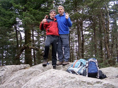
one shown in one of the guidebook photos. We had a short time alone before some other
hikers arrived and after doing us the favor of taking our picture, we headed on down the rocky
trail satisfied that we were halfway to the ultimate 48-state goal.
The distance for the day, courtesy of the handheld Garmin GPS, was 5.95 miles with a two-day
total of approximately 9.5 miles.
eight state high points. Once again - with concerns about finding time during the summer
between Kevin's summer job, summer classes, and an early return to college for the fall soccer
season - we are taking advantage of his Spring break and heading to the warmer states of the
southern Appalachian Mountains. This trip is significant for two reasons - it will put us well
past the halfway point and it will cover the last of the climb vs drive options.
We set out from home in New York's Hudson Valley on a Sunday just after 6:00 AM, arriving at
Grayson Highlands State Park in Southwest Virginia by 5:00. With each of us taking two and a
half hour driving shifts the trip didn't seem too bad. The day ended with a four mile hike from
the overnight parking area on a connecting trail to the AT, then north on the AT to a nice
camping spot a little short of the Thomas Knob shelter. We didn't realize at the start that this
connecting trail added more than a half mile than the one from the neighboring day use
parking lot but it did give us some nice alternative scenery of the sometimes bare, pasture-like
hilltops. They weren't just "pasture-like", they were actually pasture as we found out when we
ran into a small herd of the wild ponies we had heard about. (Not that the manure piles were a
clue.) A few more ponies crossed the trail right in front of us in a wooded section right near
where we camped. The large, rising, full moon that evening was awesome and so bright at
night it left shadows and limited the number of stars that could be seen. Kevin slept in his
down jacket to stay cozy as the temperature dropped, possibly as low as into the 30's.
After the long drive down and because of the cold morning we allowed ourselves to sleep in a
bit. With a little more delay to photograph a tame-seeming grouse we didn't get on the trail until
8:48. It was only another 1.3 miles to the summit which was surprisingly back into a heavily
wooded area full of moss covered spruce. We initially walked right by the USGS benchmark on
a boulder in a small clearing. Others must have done the same but the trail quickly faded out
and started heading downhill so we realized our mistake. We found a second, slightly older
USGS benchmark on another nearby boulder but there was no longer a summit sign like the
one shown in one of the guidebook photos. We had a short time alone before some other
hikers arrived and after doing us the favor of taking our picture, we headed on down the rocky
trail satisfied that we were halfway to the ultimate 48-state goal.
The distance for the day, courtesy of the handheld Garmin GPS, was 5.95 miles with a two-day
total of approximately 9.5 miles.
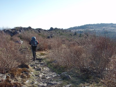
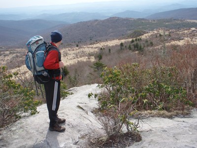
Unexpected scenery, with much
of it open and on a rocky trail.
of it open and on a rocky trail.
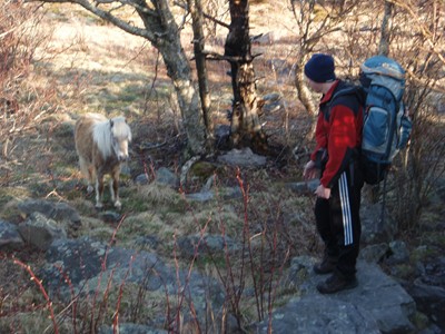
Who is checking out who? Kevin
considers trying for a pony ride.
considers trying for a pony ride.
A nice campsite on the AT mostly out
of the wind. I ran a lap to keep warm.
of the wind. I ran a lap to keep warm.
Number 24! This puts us halfway
to the big number 48.
to the big number 48.