
Sassafras Mountain
| South Carolina |
Elevation: 3,560'
Vertical Gain: 2310'
Vertical Gain: 2310'
Date: April 20, 2011
Time: 11:20 AM
Time: 11:20 AM
Weather: Breezy, overcast
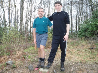
Party: Bob, Kevin
Party: Bob, Kevin
A new hiking distance personal record would be set by both Kevin and I today, by even more
than we originally expected. The pattern of the day was similar to the one before. After a
couple of hours drive from North Carolina the day before, setting up the tent, having a simple
dinner, and struggling to find dry enough wood to keep the fire going, we were in bed
reasonably early and ready to hit the trail by 7:00. The campground was in Table Rock State
Park which I selected because the trail left right from the nature center in the park. A difference
from the day before was that we had to be packed up and out of the campsite first but there
was a parking lot by the nature center and lake to move to.
Much of the first few miles of the Pinnacle Trail runs along a nice stream and makes for
pleasant hiking. A decision point came only 2.4 miles in when we reached a junction where my
guidebook clearly said to turn left but the sign called it a .4 mile spur trail and the white blazes
turned right uphill. We didn't want to do any unnecessary "exploring" since we were already
facing more than a 19 mile day but after starting uphill we hesitated thinking that if we were
wrong we would be way wrong but if the spur trail was wrong the extra mileage would be at
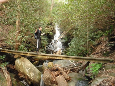
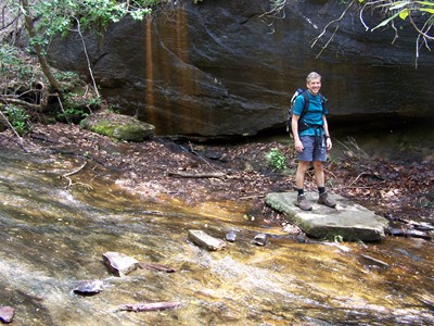
most .8 miles. So we headed down the spur trail and sure enough, at .4 miles we reached a
nice little waterfall with some branches blocking the way on the trail and a little sign on a sheet
of paper covered with plastic that said to go back because the trail was re-routed. They
couldn't put that at the beginning of the spur trail?! We briefly considered forging ahead
anyway but thoughts of having to explain how we got lost in the woods quickly dispelled that
idea. In the end, I was fine with this because it would put our day's total over the 20 mile mark -
actually 20.2 miles according to the GPS.
After backtracking to the correct route, the trail headed up to the junction with the Foothills
Trail which was only .2 miles from the summit of 3,425' Pinnacle Mountain, the second highest
peak in South Carolina. The Foothills Trail section is over 6 miles, first heading down Pinnacle,
then it is reasonably flat before ascending Sassafras. It was early in this section that we saw
the ominous clouds heading our way and soon we were in the midst of a thunderstorm and
the rain jackets had to come out. For me, it was oddly pleasant hiking since I stayed warm and
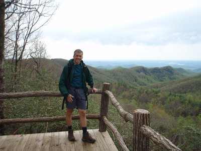
was zoned out with the rain tapping on my hood. It was all over by the time we reached the
road at the summit at 11:20 right behind an older couple who drove up. (Yes, we could have
just drove up if we weren't such purists!) After taking each others photos, the couple headed
the 100 yards or so back down to the parking lot and we were again on a summit alone. Just
off the back of the parking area there was a new, wooden observation deck which made for a
nice lunch spot. At noon, we started back the way we came (minus the detour) and finished up
at 3:25.
Not only did this hike turn out longer than expected, it also had a pretty hefty total elevation
gain of 4,275 feet. Fortunately, we had both found our stride and the footing was not as rocky
as some of the hikes further north. Although we were tired at the end, it wasn't as bad as
expected.
than we originally expected. The pattern of the day was similar to the one before. After a
couple of hours drive from North Carolina the day before, setting up the tent, having a simple
dinner, and struggling to find dry enough wood to keep the fire going, we were in bed
reasonably early and ready to hit the trail by 7:00. The campground was in Table Rock State
Park which I selected because the trail left right from the nature center in the park. A difference
from the day before was that we had to be packed up and out of the campsite first but there
was a parking lot by the nature center and lake to move to.
Much of the first few miles of the Pinnacle Trail runs along a nice stream and makes for
pleasant hiking. A decision point came only 2.4 miles in when we reached a junction where my
guidebook clearly said to turn left but the sign called it a .4 mile spur trail and the white blazes
turned right uphill. We didn't want to do any unnecessary "exploring" since we were already
facing more than a 19 mile day but after starting uphill we hesitated thinking that if we were
wrong we would be way wrong but if the spur trail was wrong the extra mileage would be at
most .8 miles. So we headed down the spur trail and sure enough, at .4 miles we reached a
nice little waterfall with some branches blocking the way on the trail and a little sign on a sheet
of paper covered with plastic that said to go back because the trail was re-routed. They
couldn't put that at the beginning of the spur trail?! We briefly considered forging ahead
anyway but thoughts of having to explain how we got lost in the woods quickly dispelled that
idea. In the end, I was fine with this because it would put our day's total over the 20 mile mark -
actually 20.2 miles according to the GPS.
After backtracking to the correct route, the trail headed up to the junction with the Foothills
Trail which was only .2 miles from the summit of 3,425' Pinnacle Mountain, the second highest
peak in South Carolina. The Foothills Trail section is over 6 miles, first heading down Pinnacle,
then it is reasonably flat before ascending Sassafras. It was early in this section that we saw
the ominous clouds heading our way and soon we were in the midst of a thunderstorm and
the rain jackets had to come out. For me, it was oddly pleasant hiking since I stayed warm and
was zoned out with the rain tapping on my hood. It was all over by the time we reached the
road at the summit at 11:20 right behind an older couple who drove up. (Yes, we could have
just drove up if we weren't such purists!) After taking each others photos, the couple headed
the 100 yards or so back down to the parking lot and we were again on a summit alone. Just
off the back of the parking area there was a new, wooden observation deck which made for a
nice lunch spot. At noon, we started back the way we came (minus the detour) and finished up
at 3:25.
Not only did this hike turn out longer than expected, it also had a pretty hefty total elevation
gain of 4,275 feet. Fortunately, we had both found our stride and the footing was not as rocky
as some of the hikes further north. Although we were tired at the end, it wasn't as bad as
expected.
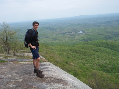
Mission accomplished! At the
summit marker.
summit marker.
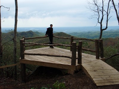
The observation deck just off
the summit is new.
the summit is new.
Made it! I think Kevin was hoping
for a shot of me falling in.
for a shot of me falling in.
Dead end! Oh well, what's another
mile when you are doing 20?
mile when you are doing 20?
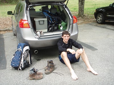
Satisfaction and tired feet.